UPDATE: A tornado watch has been issued for northern Illinois. The watch was issued by the National Weather Service at 1:55 p.m. Thursday and is set to expire at 9 p.m. Thursday.
The entire northern Illinois region, from the Mississippi River to Indiana, were under a tornado watch, as was much of central Illinois.
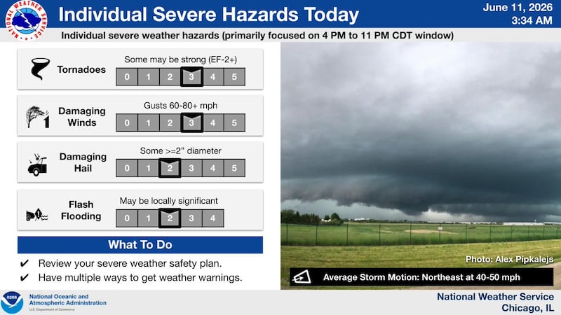
The tornado watch comes ahead of an evening storm system that carries a risk for tornadoes. The National Weather Service said earlier Thursday there is a threat for strong tornadoes for much of Northern Illinois from 4 to 8 p.m. Thursday.
More severe weather is expected Thursday, with threats of damaging winds, hail, heavy rains and even tornadoes.
The high temperatures and humidity levels will also return.
The first round will be between 11 a.m and 3 p.m., followed by the second round hitting between 4 and 11 p.m. as it moves across the region, the National Weather Service said.
In addition to the high winds and tornado threat, residents should be prepared for flash flooding that may occur where thunderstorms repeatedly hit the same area, forecasters said.
:quality(70)/cloudfront-us-east-1.images.arcpublishing.com/shawmedia/KG64UEZG5BAQ3A5SVYFWIR5UAE.jpg)
Thursday’s storms come one day after much of northern Illinois was hit hard by severe weather Wednesday afternoon and evening.
ComEd reported that more than 186,000 customers were without power as of 7 a.m. Thursday.
Residents will feel some relief after Thursday as forecasters say cooler, less humid weather is on its way Friday and the weekend.
:quality(70)/author-service-images-prod-us-east-1.publishing.aws.arc.pub/shawmedia/8832388b-fc0a-47f3-aa56-fba06c9d2015.jpg)