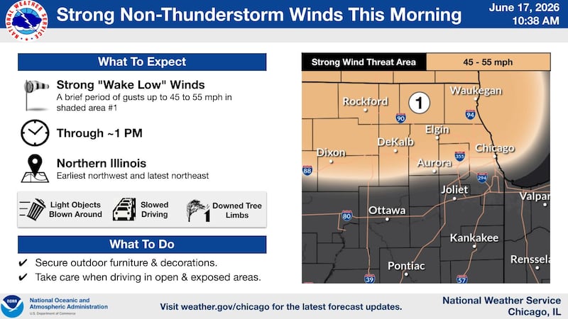
Strong winds are making their way through northern Illinois.
The National Weather Service issued a wind advisory for Boone, DeKalb, Lee, Ogle, Winnebago, north and central Cook, DuPage, Lake, Kane and McHenry counties at 10:46 a.m. Wednesday. The advisory expired at 1 p.m. Wednesday for Winnebago, Boone, McHenry, Ogle, Lee, DeKalb, Kane and DuPage counties. The advisory was still in effect until 2 p.m. for Lake and northern, central and southern Cook counties.
Winds could gust as high as 50 mph, the weather service said.
“Gusty winds will blow around unsecured objects. Tree limbs could be blown down and a few power outages may result,” the weather service said.
Driving could be difficult with winds that strong, especially for high profile vehicles. Drivers should use extra caution and people should secure their outdoor objects, the service said.
The winds come ahead of severe weather expected Wednesday. Much of northern Illinois is under a flood watch until later Wednesday.
McHenry, Boone and Winnebago counties were under a flood watch Wednesday, but were off flood watch by 1:00 p.m.
Scott Lincoln, a National Weather Service hydrologist, said the risk has decreased for flooding for McHenry and areas farther north.
Areas farther north should get half an inch or less. Areas near and south of Interstate 80 are expected to see the heaviest rainfall.
Lincoln said half an inch is enough to get ponding in some areas. But typically it is not enough to be impactful.
Ogle, Lee and DeKalb counties are under a flood watch under 5 p.m. Wednesday.
The weather bureau said creeks and streams may rise out of their banks.
More waves of rain are possible throughout the afternoon and rates could exceed an inch of rain per hour. Soil moisture and streamflow are elevated so heavy rain could result in streams or flood-prone areas, the weather service said.
Northern, central and southern Cook counties, DuPage, Ford, Grundy, Iroquois, Kane, Kankakee, Kendall, LaSalle, Lake, Livingston and Will counties are under a flood watch until 9 p.m. Wednesday.
The National Weather Service said for that watch “Creeks and streams may rise out of their banks. Flooding may occur in poor drainage and urban areas.”
More waves of heavy rain are possible through the evening Wednesday. Rainfall rates in excess of one two inches per hour are possible, the weather service said.
“Soil moisture and streamflow are already elevated, so any heavy rainfall could result in flooding of rivers, streams, urban areas, and other flood prone areas.The highest threat for flash flooding is expected near and south of Interstate 80,” the weather bureau said.
David Christensen, the director of the McHenry County Emergency Management Agency, said roadways, backyards and farm fields are more likely to flood than rivers.
While the first round of weather Wednesday is a lot of rain, the risk of severe weather goes up in the afternoon.
Hail and wind are in the forecast, and tornado activity cannot be ruled out, Christensen said.
“All hazards are expected today,” he said.
If someone has a basement prone to flooding or flooded in the spring, Christensen recommended elevating things. If your basement has a furnace or appliances, he recommended securing the power and not walking in water. For wind and tornadoes, people should be prepared to shelter in place, he said.